Testing the possibilities of visual analytics tools and mobility data sets provided information about their suitability for Helsinki’s needs
Mobility Lab Helsinki experimented with visual mobility data analytics solutions together with xyzt.ai and Geo Mobility. The proof-of-concept found different data sources available for the Helsinki region to be applicable for addressing the diverse needs of traffic planners and researchers.

Understanding traffic patterns is a basic need for traffic planning. With more and more data available, it becomes a matter of choosing the right sources and utilizing modern analytics tools to turn that data into relevant information. To address this need and to better understand what opportunities are available with state-of-the-art solutions, Mobility Lab Helsinki – the testbed for smart mobility – did a proof-of-concept pilot with xyzt.ai and Geo Mobility in the fall of 2022.
Mobility Lab Helsinki is coordinated by the city of Helsinki and its innovation company, Forum Virium Helsinki. It facilitates piloting of new services and technologies, promoting smooth, safe, and sustainable urban mobility.
“The practical experimentation we do with companies helps us discover possibilities out there that can support the city in developing its own data capabilities while also helping the companies understand the needs of the potential customers,” says Juho Kostiainen, project manager at City of Helsinki.
xyzt.ai is a company whose visual analytics platform was tested. Geo Mobility worked to bring in data sets from TomTom, HERE and Google for the period of September 2022 for testing. In addition to these, mobile network data from Telia as well as the city’s own local data sources were also explored during the pilot.
The pilot showed lots of potential for the needs of Helsinki
The use cases explored included route analysis, delay times, identifying origins and destinations of through traffic, and speeding as well as looking into the quality of different data sets themselves.
The proof of concept showed that various data sources are suitable for addressing many common needs the city has for traffic analysis. Based on this exploratory testing, the coverage and accuracy of the different data sources is sufficient, and even surprisingly good, in the Helsinki region. Floating vehicle data allows very detailed level of analysis while the telco data can useful for macro-level insights.
At first, the vast array of functionalities and filtering options on the xyzt.ai analytics platform may seem daunting, but it ultimately provides a wealth of tools for analyzing any temporal or spatial data of interest to the user. For instance, the ability to hone in on a specific street section and perform side-by-side comparisons allows for in-depth yet user-friendly analysis of traffic patterns at different times. This feature can prove extremely valuable in evaluating the effects of roadwork projects or conducting before-and-after analysis of changes to the road network.
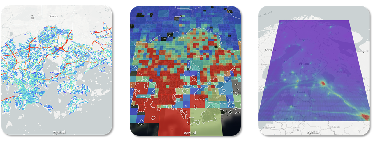
Middle: Aggregate telco data enables performing origin-destination analysis of people visiting and leaving the Helsinki region. Right: Copernicus air quality data in the xyzt.ai platform enables assessing the impact of traffic and other sources of emission on the environment.
“The experiment with xyzt.ai and Geomobility was an inspiring and also eye-opening experience for us. From the perspective of transport planning and research, information is of great importance. High-quality data allows us to understand Helsinki’s traffic better, and thus can help us make better decisions in traffic planning. I especially liked the fact that the analytics tool makes it possible for the end user to study different data sources and perform analyses as soon as there is a need for information. I was also positively surprised by the tool’s rich variety of features and how well it could potentially help us with different data needs we often face regarding traffic,” summarizes traffic researcher Katja Moilanen from the City of Helsinki.
As part of the testing, the applicability of different data sets for different needs was studied. While TomTom’s data was generally more suitable for various cases than the HERE and Google data sets, the specific needs and use cases should be defined to determine what’s the best choice.
“As an objective data provider, we put the emphasis on accuracy and objectivity. This POC allowed us to compare the different Floating Car Data providers. For each use case ranging from cut-through traffic, speeding, congestion to parking behavior, we now know the most representative source for the Helsinki area,” tells Business Development Manager Michiel Van Hove from Geo Mobility.
For the companies, this provided an opportunity to build knowledge on regional data sources, coverage, quality and challenges, and to work together with the City of Helsinki to better understand their needs and possibilities for cooperation in the future.
“Partnering with the city of Helsinki, a leader in innovation for mobility and smart city initiatives, is incredibly beneficial for a technology company like xyzt.ai. The opportunity to observe our tool in action as city analysts use it to address various mobility challenges provides valuable insights and input for our product development roadmap. It was impressive to see how the city was able to seamlessly integrate and analyze data from multiple sources, including Here, TomTom, Telia, and their own data, all within a single platform,” says CTO Bart Adams from xyzt.ai.

Photo: Vesa Laitinen, Forum Virium Helsinki